��Ƶ���������ٶȺͷֱ��ʵģ���������������������һ�ٶ���ǰ�ͺ�������ǰӢ��
�������¸绪hotel,�ʼ����У�Cambie�֣�Hasting��
Pender�֣���ʱ����ӵ�����Ļ�һ��һǧ̨��������1����ʮ�����ϵ������ˡ�
��ʱ·�����о���ָ��·�ڵģ�
Knowlton drugsһ����ǰ��ҩ�������¸绪Ӧ�û�����
һ����ǰ��ͼ��ݾ���main St�� Hastings���Ǹ�ͼ���1957��ᵽ���ڵط�
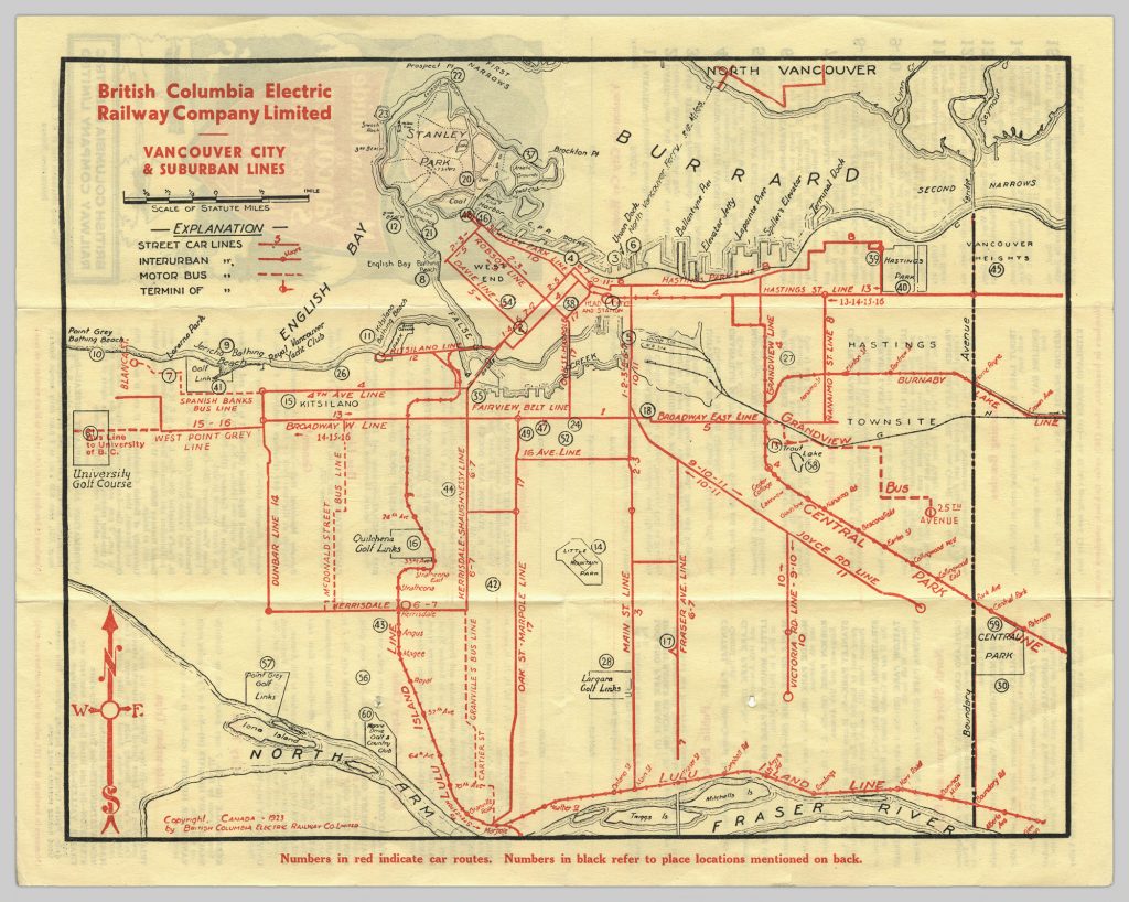
�¸绪�й�糵��·ͼ
Vancouver-Marpole
BCER began the Vancouver-
Steveston interurban and freight service in 1905 after leasing the line from
Canadian Pacific Railway (CPR) and electrifying it. The Vancouver-Marpole line's right-of-way (whose northern section runs beside Arbutus Street) remained under the ownership of the CPR, which continued running freight trains on the corridor until June 2001.
[3] With the end of freight operations on the line in sight,
Vancouver City Council adopted the
Arbutus Corridor Official Development Plan in 2000, designating the corridor as a transportation/greenway public thoroughfare to prevent other types of development from taking place along the right-of-way.
[3]Marpole-Steveston (Lulu Island Branch)
The Steveston line's alignment on
Lulu Island can be traced by Railway Avenue, Granville Avenue, Garden City Road, and Great Canadian Way. After the end of passenger service in 1958 the Granville and Garden City section of the line was relocated largely parallel to River Road north of Westminster Highway.
Marpole-New Westminster
New Westminster to Chilliwack (Fraser Valley Branch)
[align=center]

[align=left]
Vorce Station is a modest utilitarian passenger tram shelter, originally constructed at the foot of Nursery Street in Burnaby BC as part of the British Columbia Electric Railway Company's Burnaby Lake Interurban Line. In 1977 it was relocated to the grounds of the
Burnaby Village Museum.
Burnaby Lake Line
Central Park Line
Following the cessation of interurban services on the Central Park Line, the right-of-way remained under the control of
BC Hydro. By 1975, the
Greater Vancouver Regional District proposed incorporating the right-of-way into a
light rail line linking Vancouver and New Westminster,
[5] thereby reinstating passenger rail service on the corridor. The provincial government eventually took over the project, which evolved into the
Vancouver SkyTrain's
Expo Line.
[6]New Westminster to Queensborough
New Westminster to Fraser Mills
Opened in 1912,
[4] construction of ramps leading to and from the new
Pattullo Bridge resulted in the closure of the Queensborough and
Fraser Mills lines in 1937, as well as the truncation of the Burnaby Lake line to
Sapperton.
[7]Victoria to Deep Bay
Now called Deep Cove, the Victoria to Deep Cove line (1913), was one of three passenger railways to serve the
Saanich Peninsula, and was closed on November 1, 1924 due to low ridership.
[7] The Victoria-Deep Cove interurban's alignment can be traced by Burnside Road, Interurban Road and the Interurban Rail Trail, West Saanich Road, Wallace Drive, Aldous Terrace, Mainwaring Road, one of
Victoria International Airport's runways, and Tatlow Road to Deep Cove.
[8] Besides the stretch through the airport, the stretch at the Experimental Farm (now called the Sidney/Centre for Plant Health) has also been blocked.
Stave Lake
A 6-mile (9.7 km) steam train branch line,
[9] the
Stave Falls Branch, (constructed during the building of the original Stave Falls hydroelectric plant) was isolated from the main interurban network, and linked the
power plant and community at Stave Falls to the
Canadian Pacific Railway station at
Ruskin.
[7] The route of the Stave Falls Branch along
Hayward Lake is also now a walking trail managed by BC Hydro and the District of Mission, with sections of it south of
Ruskin Dam used as local powerline and neighbourhood walking trails.
Port Moody-Coquitlam
Alouette Lake
Similar to the Stave Lake and Port Moody-Coquitlam lines, the
Alouette Lake dam tracks connected power facilities to the CPR that ran on the north side of the Fraser River at Kanaka Creek in
Haney.
[10]Jordan River


 ��̳ͨ��:
 ���˿ռ�:

 ��̳ת��:


 ��
��  ����
����  Ͷ��
Ͷ�� ��
��  ����
����